 Official U.S. government information about the
Global Positioning System (GPS) and related topics
Official U.S. government information about the
Global Positioning System (GPS) and related topics

The Global Positioning System (GPS) has changed the way the world operates. This is especially true for marine operations, including search and rescue. GPS provides the fastest and most accurate method for mariners to navigate, measure speed, and determine location. This enables increased levels of safety and efficiency for mariners worldwide.
It is important in marine navigation for the ship's officer to know the vessel's position while in open sea and also in congested harbors and waterways. While at sea, accurate position, speed, and heading are needed to ensure the vessel reaches its destination in the safest, most economical and timely fashion that conditions will permit. The need for accurate position information becomes even more critical as the vessel departs from or arrives in port. Vessel traffic and other waterway hazards make maneuvering more difficult, and the risk of accidents becomes greater.
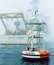 Mariners and oceanographers are increasingly using GPS data for underwater surveying, buoy placement, and navigational hazard location and mapping. Commercial fishing fleets use GPS to navigate to optimum fishing locations, track fish migrations, and ensure compliance with regulations.
An enhancement to the basic GPS signal known as Differential GPS (DGPS) provides much higher precision and increased safety in its coverage areas for maritime operations. Many nations use DGPS for operations such as buoy positioning, sweeping, and dredging. This enhancement improves harbor navigation.
Governments and industrial organizations around the world are working together to develop performance standards for Electronic Chart Display and Information Systems, which use GPS and/or DGPS for positioning information. These systems are revolutionizing marine navigation and are leading to the replacement of paper nautical charts. With DGPS, position and radar information can be integrated and displayed on an electronic chart, forming the basis of the Integrated Bridge System which is being installed on commercial vessels of all types.
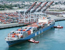 GPS is playing an increasingly important role in the management of maritime port facilities. GPS technology, coupled with geographic information system (GIS) software, is key to the efficient management and operation of automated container placement in the world's largest port facilities. GPS facilitates the automation of the pick-up, transfer, and placement process of containers by tracking them from port entry to exit. With millions of container shipments being placed in port terminals annually, GPS has greatly reduced the number of lost or misdirected containers and lowered associated operation costs.
GPS information is embedded within a system known as the Automatic Identification System (AIS) transmission. The AIS, which is endorsed by the International Maritime Organization, is used for vessel traffic control around busy seaways. This service is not only vital for navigation, but is increasingly used to bolster the security of ports and waterways by providing governments with greater situational awareness of commercial vessels and their cargo.
 AIS uses a transponder system that operates in the VHF maritime band and is capable of communicating ship to ship as well as ship to shore, transmitting information relating to ship identification, geographic location, vessel type, and cargo information -- all on a real-time, wholly automated basis. Because the ship's GPS position is embedded in these transmissions, all essential information about vessel movements and contents can be uploaded automatically to electronic charts. The safety and security of vessels using this system is significantly enhanced.
Finally, with the modernization of GPS, mariners can look forward to even better service. In addition to the current GPS civilian service, the United States is committed to implementing two additional civilian signals. Access to the new signals will mean increased accuracy, more availability, and better integrity for all users.
Note: The main text of this page has not been updated since 2006.
Benefits
- Allows access to fast and accurate position, course, and speed information, saving navigators time and fuel through more efficient traffic routing.
- Provides precise navigation information to boaters.
- Improves precision and efficiency of buoy positioning, sweeping, and dredging operations.
- Enhances efficiency and economy for container management in port facilities.
- Increases safety and security for vessels using the AIS.
“We implemented a GPS based container management system three months ago and have already seen direct benefits to our business. We have documented a 4-8% decrease in costs and a 5-10% increase in efficiency.”
LingSen Xue, General Manager, Tianjin port Container Terminals (TCT), China


