 Official U.S. government information about the
Global Positioning System (GPS) and related topics
Official U.S. government information about the
Global Positioning System (GPS) and related topics
The surveying and mapping community was one of the first to take advantage of GPS because it dramatically increased productivity and resulted in more accurate and reliable data. Today, GPS is a vital part of surveying and mapping activities around the world.
When used by skilled professionals, GPS provides surveying and mapping data of the highest accuracy. GPS-based data collection is much faster than conventional surveying and mapping techniques, reducing the amount of equipment and labor required. A single surveyor can now accomplish in one day what once took an entire team weeks to do.
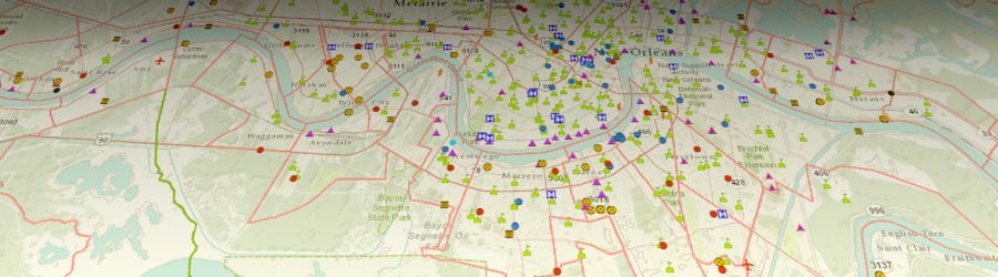
 GPS supports the accurate mapping and modeling of the physical world — from mountains and rivers to streets and buildings to utility lines and other resources. Features measured with GPS can be displayed on maps and in geographic information systems (GIS) that store, manipulate, and display geographically referenced data.
Governments, scientific organizations, and commercial operations throughout the world use GPS and GIS technology to facilitate timely decisions and wise use of resources. Any organization or agency that requires accurate location information about its assets can benefit from the efficiency and productivity provided by GPS positioning.
Unlike conventional techniques, GPS surveying is not bound by constraints such as line-of-sight visibility between survey stations. The stations can be deployed at greater distances from each other and can operate anywhere with a good view of the sky, rather than being confined to remote hilltops as previously required.
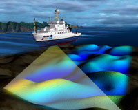 GPS is especially useful in surveying coasts and waterways, where there are few land-based reference points. Survey vessels combine GPS positions with sonar depth soundings to make the nautical charts that alert mariners to changing water depths and underwater hazards. Bridge builders and offshore oil rigs also depend on GPS for accurate hydrographic surveys.
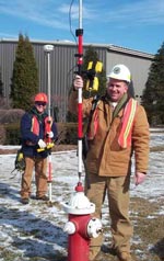
Land surveyors and mappers can carry GPS systems in backpacks or mount them on vehicles to allow rapid, accurate data collection. Some of these systems communicate wirelessly with reference receivers to deliver continuous, real-time, centimeter-level accuracy and unprecedented productivity gains.
 To achieve the highest level of accuracy, most survey-grade receivers use two GPS radio frequencies: L1 and L2. Currently, there is no fully functional civilian signal at L2, so these receivers leverage a military L2 signal using "codeless" techniques.
The ongoing GPS modernization program is adding a dedicated civil signal at L2 that supports high-accuracy positioning without the use of military signals. The GPS program is also adding a third civil signal at the L5 frequency that will enhance performance even further. After 2020, the government will no longer support codeless access to military GPS signals.
Learn more about GPS modernization
Learn more about codeless GPS access
Benefits
- Significant productivity gains in terms of time, equipment, and labor required
- Fewer operational limitations compared to conventional techniques.
- Accurate positioning of physical features that can be used in maps and models.
- Faster delivery of geographic information needed by decision makers.
- Centimeter-level surveying results in real-time.
“The most effective way to achieve a robust and globally consistent continental reference system is through the technology of the Global Positioning System (GPS). The explosive growth of GPS applications and the economics of GPS make it the technique of choice for sustainable geodetic operations within Africa.”
Claude Boucher, Former Secretary General, International Association of Geodesy (IAG)


